Raspberry Pi – Software – OpenCPN
Chartplotter and GPS Navigation Software
About
Chart Plotter and Navigational software program for use underway or as a planning tool.
Developed by a team of active sailors using real world conditions for program testing and refinement.
-
- Verified Super Clean Code
- Open Source
- Developed by Boaters
- Real-world Tested
- Updated Regularly
- Loaded with Features
- Its Free Software
Supported Chart Formats
Worldwide standard S57 and encrypted S63 vector chart support.
BSB v3 and earlier raster charts.
MBTiles chartsets.
Up-to-date ENCs for selected worldwide regions, distributed by o-charts.org
AIS
AIS input with full target-tracking and collision alerting.
AIS support for SART with selectable MMSI for automatic MOB handling.
AIS support for DSC and GPSGate buddies.
Routes
Route planning with tidal support.
Built-in great-circle routing.
Integrated weather routing plugin.
Language Support
20+ languages supported.
Performance
OpenGL support for enhanced performance on modern hardware.
GPS Tracking
Route navigation with ship tracking functions.
Waypoint navigation.
Autopilot output support.
Alarms
Anchor watch/alarm functions.
MOB Alarm with tracking.
Weather
GRIB and GRIB2 file input and display for weather forecasting.
Plugins
Over 40 plugins to choose from.
Get Plugins
User Manual
Built in for offline use.
Display
Single-chart and Quilted display modes.
Single and split-screen display.
North-up, Course-up and Chart-up.
Moving-map display mode.
Tide and Current prediction and display by location.
IHO S52 compliant display of S57 and S63 vector charts.
A selection of display themes.
InlandECDIS ver 2.3 support
NMEA Data
Dashboard for configurable on-screen display of ship’s NMEA data.
NMEA 0183 GPS interface at selectable baud rate.
Advance NMEA message handling structure with built-in multiplexer.
Data Transfer
GPX waypoints, Track and Route input and output file support.
GPX Layers for annotation of charts.
Installation
Adding OpenCPN Ubuntu PPA to Raspbian Software Sources
Once you have Raspbian running on Raspberry Pi, go to Menu → Accessories → Terminal, and type:
|
1 |
sudo nano /etc/apt/sources.list |
A text editor will open. Move the cursor to the end and add this line if you are on Raspbian Stretch:
|
1 |
deb http://ppa.launchpad.net/opencpn/opencpn/ubuntu/ xenial main |
Or, if your Raspbian is the latest Buster:
|
1 |
deb http://ppa.launchpad.net/opencpn/opencpn/ubuntu/ bionic main |
Save the file pressing Ctrl X, say Yes and press enter. Now type:
|
1 |
sudo apt install dirmngr |
(A certificate management service, needed for the next command) Then type
|
1 |
sudo apt-key adv --keyserver keyserver.ubuntu.com --recv-keys C865EB40 |
and press enter. Now be sure you have Internet connection and type:
|
1 |
sudo apt-get update |
The Software sources will be updated and finally you will have to type:
|
1 |
sudo apt-get install opencpn |
and you are done!
Installing plugins
Most plugin packages are named as opencpn-plugin-<pluginname> , to install a plugin, use a command like shown on the example below:
|
1 2 3 |
sudo apt-get install opencpn-plugin-watchdog sudo apt-get install opencpn-plugin-statusbar … |
Wildcards can be used in the installed package names, so to install all the available plugins, you may use:
|
1 |
sudo apt-get install opencpn-plugin* |
Some plugins have different names. Go to the plugins page to know the correct name:
|
1 |
sudo apt-get install oesenc-pi |
If a new version of OpenCPN or a plugin is released and you want to update (this IS a good idea), just type:
|
1 2 |
sudo apt-get update sudo apt-get upgrade |
Download Charts

You can find lots of charts on this website: http://chartcatalogs.github.io/
Chart Manual Install
Chart Downloader is the easier, preferred way to install charts, but at times manual techniques are useful.
For this example, we will use the freely distributed NOAA US charts.
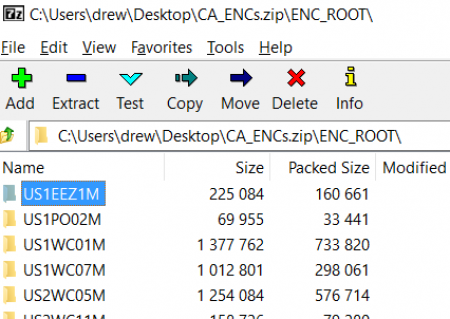
Unzip all those folders (US1EEZ1M, etc…) to a location on your hard drive. For this example we used My Documents/charts.
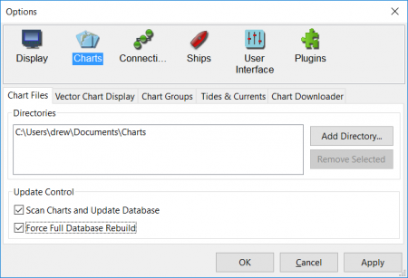
Start OpenCPN, and point it to your chart directory Settings > Charts > Chart Files > Add Directory (remember My Documents is actually something like C:\Users\user-name\Documents\Charts)
Click Select Folder
Tick boxes “Scan Charts and Update Database” and “Force Full Database Rebuild”